The subsurface conditions between a site in Hyde Park and one out toward Brandon can be night and day here in Tampa. One parcel might sit on dense, dry sand ridges while another, just half a mile away, overlies a clay-filled depression that once held a shallow lake. Developers who treat the whole region as uniform get burned fast. Electrical resistivity sounding cuts through the guesswork by mapping how current flows through the ground, and it does it without ripping up the site with a trackhoe. We run vertical electrical soundings—often called VES—to spot lateral changes in moisture, clay content, and, critically, the air-filled voids that signal karst activity in the limestone beneath Tampa. For projects near the Hillsborough River or along the Bayshore corridor, combining resistivity data with a CPT program gives us a continuous cross-check between electrical response and measured tip resistance.
In Tampa's karst terrain, resistivity is less about finding rock and more about finding the holes in it before they find your foundation.
Our approach and scope
Site-specific factors
Tampa's growth from a late-19th-century phosphate port into a sprawling metro has meant building on everything from reclaimed marsh to ancient dune fields. Older neighborhoods like Seminole Heights got platted before anyone knew what karst even meant, and now property owners are dealing with subsidence claims and cracked slabs that trace back to undocumented subsurface cavities. Skipping a resistivity survey in this environment is a roll of the dice. A few hundred feet of line can reveal a continuous low-resistivity zone loaded with wet clay that will settle unevenly under embankment load, or a discrete high-resistivity anomaly that screams dry void. We flag these anomalies in plan view so the structural engineer can shift column lines or the geotech can recommend targeted grouting. The cost of mobilization for a VES survey is trivial compared to the change order that hits when a drill rig drops into a cavity nobody mapped.
Reference standards
ASTM D6431-18 (DC resistivity, field procedures), ASTM D2487 (Unified Soil Classification, correlation with resistivity), IBC 2021 Chapter 18 (soils and foundations), ASCE 7-22 (seismic site class, where resistivity supports Vs correlation)
Other technical services
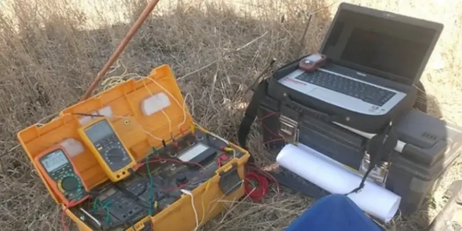
1D Vertical Electrical Sounding (VES) Package
Multi-spacing Wenner or Schlumberger soundings at gridded stations across the parcel. We deliver interpreted layer resistivity vs. depth, water table approximations, and anomaly heat maps.
2D Resistivity Imaging & Karst Screening
Long-offset dipole-dipole or Wenner-Schlumberger profiles oriented to cross known lineaments. Inversion-ready images flag sinkhole-prone zones, buried organic layers, and lateral facies changes in the Hawthorn Group.
Typical parameters
Common questions
How deep can a resistivity survey see in Tampa's geology?
It depends on the array spread and the site noise, but with a 400-foot total cable layout we typically resolve features down to about 100 to 120 feet. That covers the critical zone from the surface through the Hawthorn Group and into the top of the Ocala Limestone, where most of the karst voids we are hunting tend to occur. For deeper basin structure we extend the spread, though resolution drops off with depth.
Can resistivity tell the difference between a water-filled void and a dry cavity?
Yes, and that distinction is exactly what makes the method useful here. A dry cavity in limestone shows up as a sharp high-resistivity spike because air is an electrical insulator. A void filled with conductive, clay-rich water reads as a much lower resistivity zone. Our inversion software maps those contrasts, and we ground-truth the interpretation with local boring data whenever possible.
What does a VES survey cost for a typical Tampa residential lot?
For a standard residential or light commercial parcel, budgets generally fall between US$590 and US$1.180 depending on the number of soundings, access constraints, and whether we run a single VES station or a full 2D line. We deliver a fixed-price quote after reviewing the site plan and intended building footprint.
How do you handle sites with buried utilities and urban noise?
We start with a utility clearance call and a site walk to map overhead lines, underground works, and any metallic structures that can couple with the array. In high-noise environments we stack readings, use notch filters, and occasionally shift to a dipole-dipole geometry that is less sensitive to cultural interference. Tampa's older neighborhoods have plenty of stray current, and we have dealt with it for years.